The North Atlantic is the busiest oceanic airspace in the world, with more than 370,000 crossings annually. With limited availibility of direct controller-pilot communications and non-availibility of radar surveillance, the structure of airspace in this region is influenced by a number of factors, including passenger demand, time-zone differences, effects of jet streams, weather, and restrictions on night flying.
Perhaps the most important of all these is the effect of jet streams, which are fast-moving currents of air situated in the tropopause, at a height varying from about 4 miles at the poles (polar jet stream) to about 8 miles at lower latitudes (sub-tropical jet stream). The width of a jet stream is usually a few hundred miles and its vertical thickness, often less than three miles. The winds within a jet stream can be very strong, ranging from about 90 knots, to over 200 knots.
 |
| The jet streams are westerly currents. The polar jets are very strong and occur at lower altitudes (7-12 km above the surface), while the weaker sub-tropical jets occur at higher altitudes (10-16 km above the surface). |
 |
| The jet stream consists of meandering currents of air propagating towards the east, with wind speeds at the core often exceeding 200 knots. The winds are generally strongest just below the tropopause. |
The polar and sub-tropical jet streams are upper-level jet streams, occuring very near the tropopause, and their postions over the earth change every day, owing to pressure and temperature variations. In general, the upper-level jet streams may be said to "follow the sun", ie. they move northwards (to higher latitudes) during summer and southwards (to lower latitudes) during winter. Due to this daily variation in position, shape, and altitude at which jet streams occur, favourable paths across the North Atlantic accordingly vary on a daily basis.
NORTH ATLANTIC (NAT) ORGANIZED TRACK SYSTEM (OTS)
The North Atlantic tracks are air routes that are published daily, taking into consideration the varying nature of the jet streams. As much as the jet streams significantly reduce flight duration (and fuel burn) for east-bound flights, they increase flight duration (and fuel burn) for west-bound flights. Air routes are optimized for minimum time, by chosing those routes that have maximum tailwinds and minimum headwinds. East-bound and west-bound routes are published daily by Shanwick Centre (EGGX) and Gander Center (CZQX) respectively, in consultation with adjacent oceanic area control agencies (OACs). Due consideration is given to airlines' preferred routing and airspace restrictions such as danger/military areas while planning these routes. Passenger demand and time-zone differences have resulted in two major sets of daily routes being published, a west-bound flow departing Europe in the morning, and an east-bound flow departing North America in the evening.
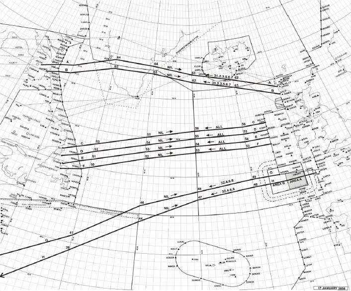 |
| Day-time west-bound tracks published by Shanwick Center (EGGX). |
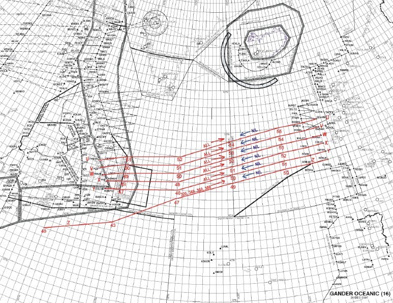 |
| Night-time east-bound tracks published by Gander Center (CZQX). |
The above mentioned system of air routes that are published daily is also called "Organized Track System" (OTS), and is just one of the many air routes within/adjacent to the NAT airspace, such as the "Blue Spruce" routes and the North American routes (NARs).
 |
| Other routes within the NAT airspace that are not part of the Organized Track System (OTS). |
MINIMUM NAVIGATION PERFORMANCE SPECIFICATIONS (MNPS)
With the non-availibility of radar surveillance and limited direct controller-pilot communications over the NAT, aircraft separation assurance and safety is ensured by requiring exacting standards of horizontal and vertical navigation performance and operating discipline. For this reason, the organized track system has been designated as MNPS airspace, and all flight operations that are intended to be carried out in such airspace are first required to be approved with respect to navigational/other equipment capabilities, their installation and maintenance procedure, aircrew training and qualifications, etc. by the state regulatory authority. Formal monitoring programmes are undertaken to quantify the achieved performances and compare them with standards required to ensure that established Target Levels of Safety (TLS) are met. If a deviation is identified, follow-up action after the flight is taken, both with the operator as well as the state of registry of the aircraft, to ascertain the cause of the deviation and to confirm further operability in MNPS airspace.
Currently, MNPS airspace extends vertically between FL285 and FL420 (in terms of normal cruising levels, FL290 to FL410 inclusive). MNPS airspace falls under RVSM (Reduced Vertical Separation Minimums) airspace and cruising flight levels are separated vertically by 1000 feet.
The lateral dimensions of MNPS airspace include the following control areas:
REYKJAVIK, SHANWICK, GANDER, and SANTA MARIA OCEANIC plus that portion of NEW YORK OCEANIC north of 27 deg. N and excluding the area west of 60 deg. W and south of 38 deg. 30 min. N. The diagram given below describes the lateral extent of the NAT MNPS airspace:
 |
| Lateral extent of NAT MNPS airspace. |
FLYING IN NAT MNPS AIRSPACE
NAVIGATION
Unlike navigation over land, where there are sufficient ground navigation facilities like VORs and NDBs at reasonable distances apart, using which position checks can be made, navigation over the ocean is quite different, and requires long range navigatonal aids like global navigation satellite systems (GNSS - GPS navigation, for all practical purposes). Lack of radar coverage implies that the controllers will have to rely on position reports sent from the aircraft in order to maintain separation and manage traffic flow across the routes.
The defining waypoints of OTS tracks are specified by whole degrees of latitude and, using an effective 60 NM lateral separation standard, most adjacent tracks are separated by only 1 deg. of latitude at each 10 deg. meridian. It is therefore imperative that MNPS include technical navigation accuracy to be maintained and monitored. The NAT MNPS requires that the lateral track deviation error is less than 6.3 NM on either side of course (or 12.6 NM total lateral track error), for 95 % of the time. Even before the advent of GPS, the equipment on board most commercial aircraft achieved exceeded this requirement, with standard track deviations of about 2 NM.
Today, in the NAT airspace system, the predominant source of aircraft positioning is that of GPS. This includes aircraft that use stand-alone equipment as well as aircraft that have an integrated navigation solution (GPS + IRS, etc). The accuracy of GPS is such that the flight paths of any two GPS equipped aircraft navigating to a common point will almost certainly pass that point within less than a wingspan of each other !
COMMUNICATIONS
Most NAT air-ground communications use single side-band high frequency (HF) radio communications. Pilots communicate with oceanic area controllers (OAC) via aeradio stations staffed by communicators who have no executive ATC authority. Messages are relayed from the ground station to the air traffic controllers in the relevant OAC for action. In the NAT, there are six aeronautical radio stations, one associated with each of the oceanic control areas (OCAs). They are BODO RADIO (Norway, Bodo ACC), GANDER RADIO (Canada, Gander OACC), ICELAND RADIO (Iceland, Reykjavik ACC), NEW YORK RADIO (USA, New York OACC), SANTA MARIA RADIO (Portugal, Santa Maria OACC), and SHANWICK RADIO (Ireland, Shanwick OACC). The aeradio stations and the OACs are not necessarily co-located. Twenty-four HF frequencies have been allocated, in bands ranging from 2.8 Mhz to 18 Mhz, for communications in the NAT region. Due to diurnal variation in the intensity of ionisation in the refractive layers of the atmosphere, higher frequencies (greater than 8 Mhz) are chosen for communications during the day, and lower frequencies (less than 7 Mhz) are chosen at night. An aircraft on a trans-atlantic flight is generally allocated a primary and secondary HF frequency when it receives its clearance from domestic controllers shortly before entering oceanic airspace. Even with more advanced communications technology in the cockpit, like datalink communications (CPDLC) and satellite communications (SATCOM), carriage of HF equipment on board is always recommended (and is sometimes mandatory in some oceanic areas, like Shanwick OACC). Selective Calling (SELCAL) provides for the aircrew to be alerted by controllers, if and when necessary, and relieves the aircrew of having to maintain a listening watch on the communications frequency.
 |
| Major World Air Route Areas (MWARA) HF radio frequency coverage in the NAT region. |
An often encountered problem with HF communications is poor radio wave propagation (due to ionospheric disturbances), also know as "HF black-out", in which case the aircrew follow established rules and procedures for radio communications failure, like for example, relaying messages on a VHF frequency, with the help of a nearby aircraft/radio station, or landing at a nearby airport. Today, with more aircraft being equipped with modern technology like SATCOM, HF black-out seems to be less of a safety issue as it has been in previous years.
PREFLIGHT
Assuming that all required equipment is certified and working properly, it has to be ensured that the Inertial Reference System (IRS) is accurately aligned before flight, and that the actual position of the aircraft, at alignment, is set into the system - failing which systematic errors will be introduced. While inserting waypoints into the flight computers, aircrew must verify the latitude and longitude co-ordinates with an accurate "master-document" in order to avoid gross navigation errors. In fact, special training is required in the insertion of way-points for MNPS operations, with relevant cross-checks being performed by the aircrew to ensure accuracy of the information being input.
INFLIGHT
During the initial part of the flight, ground based navigational aids are used to check the accuracy of the long range navigational systems (LRNs). It would be very unwise to continue the flight if very large "map shifts" are found to occur. Aircrew must be trained and familiar with receiving oceanic clearances. Routine navigational accuracy checks must be performed, and position reports made when necessary. Sometimes, meteoroligical reports might be required to be made to ATC, like for example, winds and outside air temperature.
Even though ATC clearances are designed to ensure that separation and safety standards are continually maintained, error do occur. Gross navigation errors (caused by mistakes in entering waypoints) are made, and aircraft are sometimes flow at flight levels other than those assigned by the controller. Consequently, it has been determined that allowing aircraft to fly self-selected lateral offsets during oceanic flights, will provide additional safety margins and mitigate the risk of traffic conflicts, should non-normal errors (such as navigation errors, flight-level deviation errors, or turbulence induced altitude changes) occur. These procedures are termed "Strategic Lateral Offset Procedures" (SLOP) and collision risks are significantly reduced by applying these offsets.
The magnetic compass is rendered unuseable, when flying close to the earth's north magnetic pole. Within NAT MNPS airspace, the northwest of Greenland, and also some parts of Canadian airspace, are areas of compass unreliability. Enroute charts show these areas, and basic inertial navigation systems require no special procedures here. However, special aircrew training may be required for flight operations in these areas.
Very long range operations might include the use of relief crew. It must be ensure that crew change does not interfere with the continuity of the flight, especially in the handling and treatment of navigational information.
POST FLIGHT
On completion of a trans-atlantic flight, navigational equipment is checked for errors, and follow-up action is taken as required.
ADDITIONAL EQUIPMENT REQUIREMENT
Depending on the flight operation, aircraft may need to be equipped with Aircraft Collision Avoidance Systems (ACAS/TCAS), have dual long-range navigation systems (LRNs), and other such equipment in the interest of safety.
Click here for a more comprehensive reading on NAT MNPS.
No comments:
Post a Comment